Tuesday, March 30, 2010

The Charmaadi Babes


These are pics of some fantastic natural creations along the Charmaadi Range in the Western Ghats. These pics are collected from over the global-net of Charmaadi Enthusiasts. Enjoy the sight....

1. Etthina Bhuja
That's Etthina Bhuja peak near Shishila

Down below the Etthina Bhuja


2. Amedikallu peak
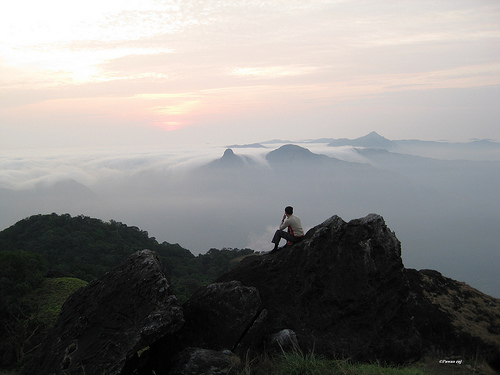
Amedikallu Peak, the highest among the Charmaadi Peaks

Enroute to Amedikallu peak....

From its foot, Amedikallu peak


3.Ballalarayanadurga Fort


4. Shingani Gudda


Sheengani Gudda just after the rains................!!!!!!!


5.Charmadi ghats enroute Mudigere to Mangalore


These pics are taken from the Mangalore-Mudigere Road


6. Minchukallu Gudda

Minchukallu is on the right side...


6. Balekallu Gudda


7. Erikallu and Kodekallu peaks


Thats enough for now na...... A huge thanks for the real photographers of this stuff, cos you are among those who would drive us to these places....

Sunday, March 28, 2010

Kumaraparvatha-The toughest mountain ride in Karnataka


This is a post for hikers, trekkers and nature lovers on one of the most beautiful places in the Western Ghats- The Kumaraparvatha Range of Mountains.

The Kumara Parvatha(KP) range is located in the heart of the steepest Western Ghats near the famous town of Kukke Subrahmanya. The historical and religious background of these mountains are directly connected to this place, which is famous for Serpant Worship. The KP range is about 12 km from Subrahmanya which is around 280 km from Bangalore and 105km from Mangalore. Subrahmanya is accessible by buses and trains from both these cities and other major cities of the state. The range of mountains are geographically present in Somavarpet Taluq, Kodagu District from where the ride begins or ends on the other end of the trail.

The KP range consists of 4 mountains of almost same size namely, Bhatthada Raashi(Kallu Chappara Mountain), Shesha Parvatha(The Seven hood Serpant), Siddha Parvatha(Maarigundi) and the Pushpagiri, in order of reachability from Subrahmanya. The highest being Pushpagiri is at an altitude of 1759mts from sea-level. Pushpagiri is also a sacred place for its peak has a small place of worship, that houses the engraving of Lord Subrahmanya's foot on the rocks. It is believed that the Lord rested in Pushpagiri after destroying the gaint Thaarakasura. There exists a prominent 19km trail from Subrahmanya that covers 3 peaks and finally reaches Bidalli, Somavarpet Taluq.

The trail to these ranges is the most adventurous and straining one, which begins near the house of Shree Parashurama Acharya at Subrahmanya. It takes us through a strenuous ride of 5 kms through the dense forests and a place of water-stream(Bheemanakallu) to a place called Girigaddhe. This is the only place of human habitation throughout the trail. It is a small village consisting of one family that lives on mountain-agriculture. This family has been of great help to the hikers as it provides food and shelter on request at an affordable price, like a base camp at the midst of the trail. Popularly called the Bhattara Mane, the family grows arecnut, vegetables and other crops for the living. The place also has a forest checkpost, in order to restrict any kind of harmful material to be carried during the rest of the trek.


From Girigaddhe, the first peak that we come accross is the Bhatthada Raashi. It is an open-grass gaint structure that is prominently visible from Subrahmanya. This mountain, at its neck, consists of a probably 500 year old stone complex called the Kallu-Chappara, which is believed to be a relaxing place for people who used to travel these routes in olden days. From this mountain, the trail takes us through a very tough ride to the Shesha Parvatha. This peak is a magnanimous one for its structure, slope from one side and a 2000ft drop on the other. This gives an impression of the hood of a serpent, and thus the name. From this peak one can have a glorious view of Maarigundi (Siddhaparvatha), which is a single rock that looks rubbed against natural forces,like rains, moist-degradation of rocks and land slides. This place is believed to be the one where Lord Subrahmanya killed Thaarakasura. From Shehaparvatha, another strenous ride through the forests and rocks takes us to the final destination, Pushpagiri.


Pushpagiri, also known as Kumaraparvatha peak, is known for its natural beauty,diverity and sacredness. Its like an open stadium at the peak that can have a 100 people at once. It consists of a small shrine about which I had told previously. A very good place for a night's rest after a strenuous ride. The peak is also famous for a special type of Hexagonal shaped stone, called Kumaralinga, and is collected and worshipped as lord Shiva by people of faith. It is indeed a tough task to search for these stones there and many people add up to the competition due to its sacredness.


From Pushpagiri, it is a continuous descent of around 6km to a village called Biddalli, from where human habitation can be finally observed.


I have attached a lot of spectacular pics from my picasa album which is a collection of photos taken by many trekkers who rode to this place. I hope this creates a spark in your senses about the place and drive you to feel its beauty.

Click here for photos.


Trek Earth - Destinations